  Angel Falls (Venezuela) (also called Salto Angel) is the Earth's highest uninterrupted waterfall. It is 979 metres (3,230 feet) tall - think of it as 2.5 times as tall as the Empire State Building and full 15 times higher than Niagara Falls!    The view from the top is fantastic enough to inspire a multitude of "Lost World" legends (including the famous Conan Doyle book), not to mention the table-top mountain itself - a wonder-world of vegetation and species found nowhere else on Earth.  |
Saturday, December 21, 2013
The Angel Falls
Friday, December 20, 2013
The Waitomo Glowworm Caves


The Waitomo Glowworm Caves, located just outside the main
Waitomo township on the North Island of New Zealand, is a famous attraction
because of a sizeable population of glowworms that live in the caves. Glowworms
or Arachnocampa luminosa are tiny, bioluminescent creatures that produce a
blue-green light and are found exclusively in New Zealand. They are around the
size of an average mosquito. This cave is part of the Waitomo Caves system that
includes the Ruakuri Cave and the Aranui Cave.

The Waitomo Glowworm Caves were first explored in 1887 by
local Maori Chief Tane Tinorau accompanied by an English surveyor Fred Mace.
Local Maori people knew of the Caves existence, but the subterranean caverns
had never been extensively explored until Fred and Tane went to investigate.
They built a raft of flax stems and with candles in hand, floated into the cave
where the stream goes underground.

As they entered the caves, they came across the Glowworm
Grotto and were amazed by the twinkling glow coming from the ceiling. As they
travelled further into the cave by poling themselves towards an embankment,
they were also astounded by the limestone formations.

The Aurora

An aurora is a natural light display in the sky particularly
in the high latitude (Arctic and Antarctic) regions, caused by the collision of
energetic charged particles with atoms in the high altitude atmosphere
(thermosphere). The charged particles originate in the magnetosphere and solar
wind and, on Earth, are directed by the Earth's magnetic field into the
atmosphere. Most auroras occur in a band known as the auroral zone, which is
typically in 3° to 6° latitudinal extent of geographical poles, or
equivalently, 10° to 20° latitudinal extent of geomagnetic poles, and at all
local times or longitudes. During a geomagnetic storm, the auroral zone expands
to lower latitudes.

In 1621, a French scientist, Pierre Gassendi, saw the lights
in the north and named after the Roman goddess of dawn, Aurora. He added the
word "borealis" for the Roman god of the north wind, Boreas. These aurora
borealis are also known as Northern Lights.

In the southern hemisphere, they are called aurora
australis, meaning "southern." The lights are usually seen after dusk
near both poles.


Venice

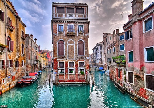

Venice is a city in northeastern Italy sited on a group of 118 small islands separated by canals and linked by bridges. It is located in the marshy Venetian Lagoon which stretches along the shoreline, between the mouths of the Po and the Piave Rivers. Venice is renowned for the beauty of its setting, its architecture and its artworks. The city in its entirety is listed as a World Heritage Site, along with its lagoon.


The name is derived from the ancient Veneti people who inhabited the region by the 10th century BC. The city historically was the capital of the Republic of Venice. Venice has been known as the "La Dominante", "Serenissima", "Queen of the Adriatic", "City of Water", "City of Masks", "City of Bridges", "The Floating City", and "City of Canals". Luigi Barzini described it in The New York Times as "undoubtedly the most beautiful city built by man". Venice has also been described by the Times Online as being one of Europe's most romantic cities.

The Republic of Venice was a major maritime power during the Middle Ages and Renaissance, and a staging area for the Crusades and the Battle of Lepanto, as well as a very important center of commerce (especially silk, grain, and spice) and art in the 13th century up to the end of the 17th century. This made Venice a wealthy city throughout most of its history. It is also known for its several important artistic movements, especially the Renaissance period. Venice has played an important role in the history of symphonic and operatic music, and it is the birthplace of Antonio Vivaldi.

Thursday, December 19, 2013
The Sigiriya Rock Fortress

The Sigiriya Rock Fortress of Sri Lanka is situated in Matale district near to Dambulla. It can be reached along Colombo- Habarana highway and turning towards East from Inamaluwa. Then proceeding about 10 km from Inamaluwa and passing Kimbissa township one arrives at Sigiriya.
Before Sigiriya became a Kingdom, the Sigiriya Rock base and the places such as Pidurangala which were endowed with many Caves and a temple had been dwelled by Buddhist monks from around 3rd Century BC. It is also found that these areas had been inhabitant by people prior to King Kassapa's rein. Many Caves also have Brahmi Inscriptions dating back from 3rd Century BC to 1st century AD.

Sigiriya was rediscovered during the rule of the British, by Major H. Forbes in 1831. Climbing of the Sigiriya summit was achieved by A.H.Adams and J.Bailey in 1853.

Sigiriya being a fortress, had been well designed for its defenses by having ramparts and moats built around it. There are several approaches to the inner city and the most prominent is the Western entrance. From the summit of the rock, the land areas up to distances of tens of miles can be watched making it hard for the enemy to make a surprised attack to the kingdom.


The most renowned is the Sigiriya Rock Paintings or Frescoes of Sigiri Damsels locally called as 'Sigiri Apsaras' painted on a Western Rock face cavity about 100 meters high from the rock base. There now remains around 21 paintings of Sigiriya Damsels but there had been around five hundred paintings during King Kassapa's' time along several other places of the same Western Rock face.

Another interesting construction is the Mirror Wall,
which is covered with graffiti from the 7th to the 10th centuries AD. These
were written by the people came to see Sigiriya during those long years. Coming
along the path of the mirror wall, one find the Lion Paw Terrace or Platform.
Only two huge Lion's paws are remaining now but earlier there had been an
enormous Lion figure or statue at the entrance. Through the Lion's paw
stairway, the summit can be reached taking the iron stairway built on to the
rock face. On the summit are the remains of the Palace building foundations and
few ponds on a area of about 3 acres of rock summit. The largest pond was made
by cutting out the rock and it is assumed that utilizing the great wind force
occurring on the summit, water was brought up to fill this tank by a hydraulic
system using wind power from the ground level. Some hundreds of interesting
Sigiriya Fortress images are being included here.
Mount Everest
Mount Everest is the Earth's
highest mountain, located in the Mahalangur section of the Himalayas. Its peak is 8,848 metres (29,029 ft) above sea level and
the 5th furthest point from the centre of the Earth. The international border between China and Nepal
runs across the precise summit point. Its massif includes neighboring peaks Lhotse, 8,516 m (27,940 ft); Nuptse, 7,855 m (25,771 ft) and Changtse, 7,580 m (24,870 ft).


In 1856, the Great Trigonometric Survey of India
established the first published height of Everest, then known as Peak XV,
at 29,002 ft (8,840 m). The current official height of 8,848 m
(29,029 ft) as recognized by Nepal and China was established by a 1955
Indian survey and subsequently confirmed by a Chinese survey in 1975. In 1865,
Everest was given its official English name by the Royal Geographical Society upon a recommendation by Andrew Waugh,
the British Surveyor General of
India. Waugh named the mountain after his
predecessor in the post, Sir George Everest.
Although Tibetans had called Everest "Chomolungma" for centuries,
Waugh was unaware of this because Tibet and Nepal
were closed to foreigners at the time thus preventing any attempts to obtain
local names.

Mount Everest attracts many highly
experienced mountaineers as well as capable climbers willing to hire
professional guides. There are two main climbing routes, one approaching the
summit from the southeast in Nepal (known as the standard route) and the other
from the north in Tibet. While not posing substantial technical climbing
challenges on the standard route, Everest presents dangers such as altitude
sickness, weather, wind as well as
significant objective hazards from avalanches and the Khumbu
Icefall. While the overwhelming majority of
climbers will use bottled oxygen
in order to reach the top, some climbers have summitted Everest without
supplemental oxygen.

The first recorded efforts to reach
Everest's summit were made by British mountaineers. With Nepal not allowing foreigners into the country at the
time, the British made several attempts on the north ridge route from the
Tibetan side. After the first reconnaissance
expedition by the British in 1921
reached 7,000 m (22,970 ft) on the North Col, the 1922 expedition pushed the North ridge route up to 8,320 m
(27,300 ft) marking the first time a human had climbed above 8,000 m
(26,247 ft). Tragedy struck on the descent from the North col when seven
porters were killed in an avalanche. The 1924 expedition resulted in the greatest mystery on Everest to this day: George
Mallory and Andrew Irvine made a final summit attempt on June 8 but never returned,
sparking debate as to whether they were the first to reach the top. They had
been spotted high on the mountain that day but disappeared in the clouds, never
to be seen again until Mallory's body was found in 1999 at 8,155 m
(26,755 ft) on the North face. Tenzing
Norgay and Edmund
Hillary made the first official ascent of
Everest in 1953 using the southeast ridge route. Tenzing had reached
8,595 m (28,199 ft) the previous year as a member of the 1952 Swiss
expedition.

Saturday, December 14, 2013
The Taj Mahal
The Taj Mahal is
the epitome of Mughal art and one of the most famous buildings in the
world. Yet there have been few serious studies of it and no full
analysis of its architecture and meaning. Ebba Koch, an important
scholar, has been permitted to take measurements of the complex and has
been working on the palaces and gardens of Shah Jahan for thirty years and on the Taj Mahal itself—the tomb of the emperor's wife, Mumtaz Mahal—for a decade.

The tomb is the representation of the house of the queen in Paradise, and its setting was based on the palace gardens of the great nobles that lined both sides of the river at Agra, India. You will explore the entire complex of the Taj Mahal with an explanation of each building and an account of the mausoleum's urban setting, its design and construction, its symbolic meaning, and its history up to the present day.
 Taj Mahal
was built in 22 years (1631-1653) with the orders of Shah Jahan and it
was dedicated to Mumtaz Mahal (Arjumand Bano Begum), the wife of Shah.
20.000 workers labored and 32 crore rupees were spent during the
construction of the monument, and it was built using marble, according to Islamic
architecture. It is one of the UNESCO world heritage site.
Taj Mahal
was built in 22 years (1631-1653) with the orders of Shah Jahan and it
was dedicated to Mumtaz Mahal (Arjumand Bano Begum), the wife of Shah.
20.000 workers labored and 32 crore rupees were spent during the
construction of the monument, and it was built using marble, according to Islamic
architecture. It is one of the UNESCO world heritage site.


The tomb is the representation of the house of the queen in Paradise, and its setting was based on the palace gardens of the great nobles that lined both sides of the river at Agra, India. You will explore the entire complex of the Taj Mahal with an explanation of each building and an account of the mausoleum's urban setting, its design and construction, its symbolic meaning, and its history up to the present day.

The Interior of Taj Mahal


Subscribe to:
Posts (Atom)